Oyvassrunden

Advertisement

3540
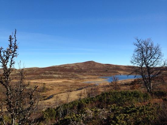
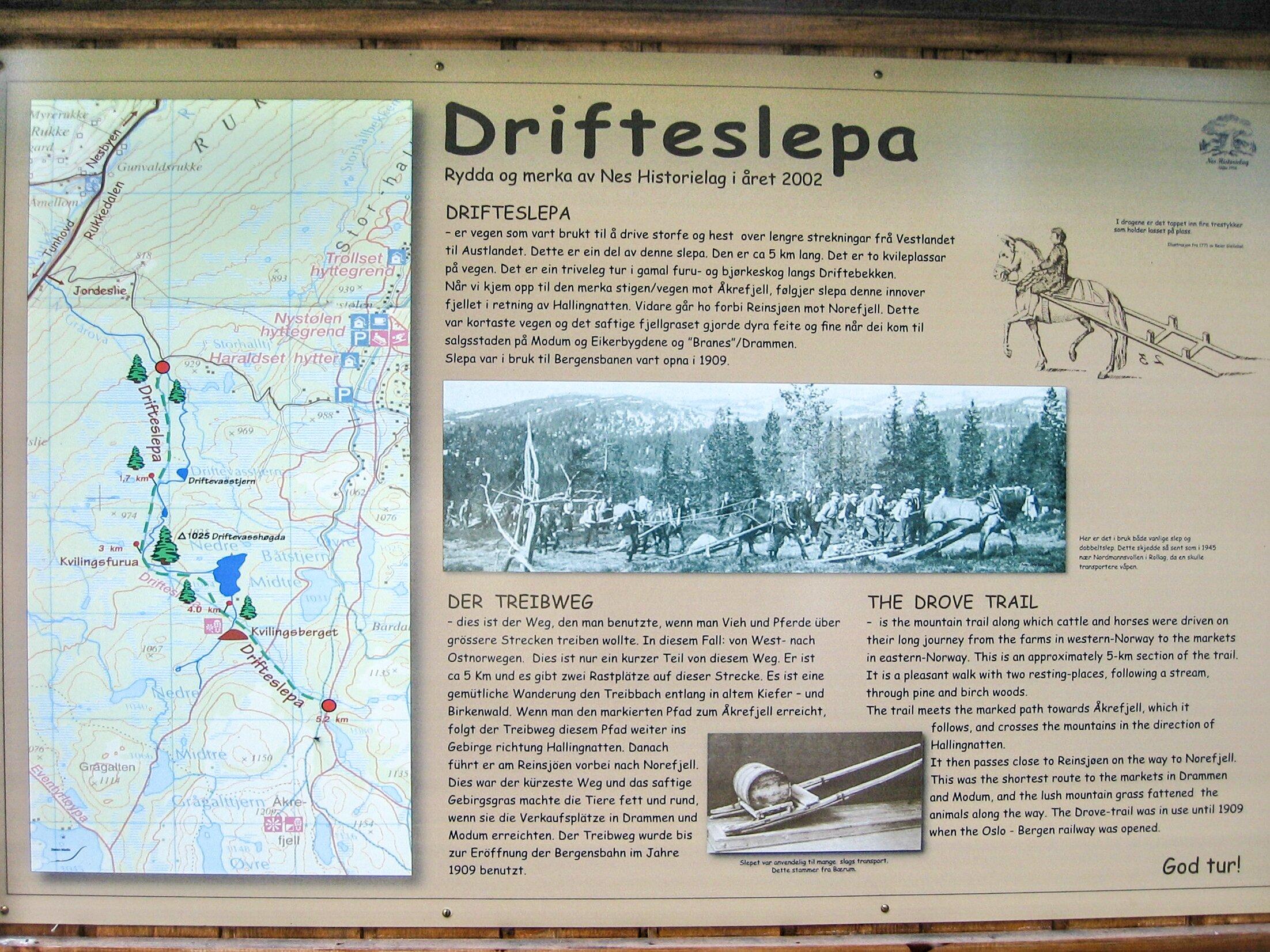
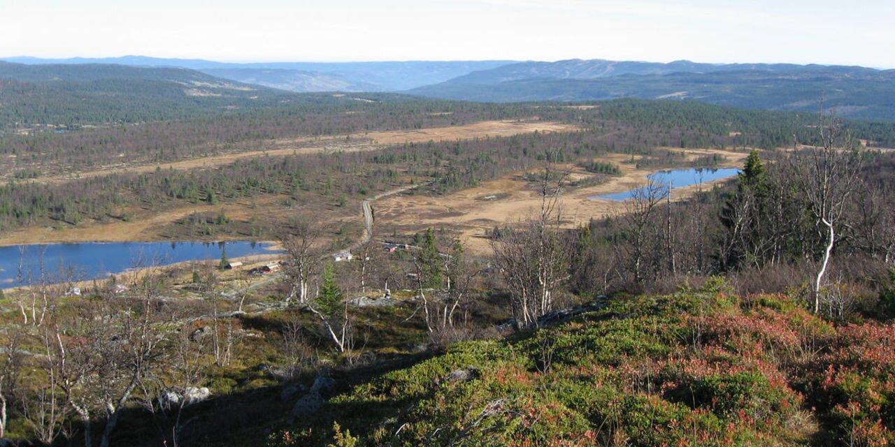
Mountain terrain. 970-1150 m.a.s.l. Follow the marked trail from Nystolen over the mountainside Batstjernlia. The trail forks after the lakes Batstjernene. Here you can take a shorter rout to the left it will put you back on the route right above the crossroad to the mountain Trommenatten. The trail inwards meets up with the historical slope Drifteslepa. The route forks on a small mound just before the hill up to the mountain akrefjell (1208 m.a.s.l.). Great view from the heights between the mountains akrefjellvannet and oyvatn. The trail forks in the steepest hill by the lake oyvatn. Go left towards the Trommenatt tarns and Timmermannsstolen. You’ll cross some mounds and marshes (the marsh trail is reinforced with planks, but good shoes are recommended). This is where the shorter route joins the trail. Further down, get on a grassy car road to the summer farm Timmermannsstolen. From there the starting point is not far away. Starting point: Trondrudmarka. Parking: Nystolkroken Kafe or Storhalle Directions: From Nesbyen town center, Rukkedalsvegen 8 km towards Tunhovd. Go left over river towards Nystolen 3 km. Go right towards Nystolen 5 km Km: 10 km starting at the road Jordeslivegen, 11 km from Nystolkroken Kafe. Normal pace: 3 - 5 hrs Signs: Sign-posted and marked with red color. Wooden signs. Recommended stops: akrefjell, Trommenatten. Hiking map can be bought at the tourist information, bookstore and at tourist businesses. GPS: 0495121o - 6703919N
Own this business?
See a problem?

You might also like

The Cattle Trail in Nesbyen

The Cattle Trail in Nesbyen

1
This is a small part of an old cattle road that went from Aurland in Sogn and crossed Hallingdal just below Sundre. The road then turned towards Nesningsfjella, Skalsrudstolen, Rukke and further up to Jordeslia, where there was a rest stop on one of the summer farms. ”Our” road starts just above Jordeslia and follows Driftevassbekken creek upwards. Just 200 m from the starting point, the historical society has built a small bridge over the creek. There's an info sign here. About 3 km further on, the road passes a giant pine tree. Jorgen Holm has named it Kvilningsfuro, The Rest Pine. An examination of the growth rings revealed that the tree is about 550 years old a living organism from medieval times. A visit to the pine is worth the hike in itself. There's an info board and 2 good benches by the tree. About 1 km further, you'll arrive at Kvilningsberget, The Rest Rock. There are benches here as well and a great view towards the Hemsedal mountains and Reineskarvet. You can also see Hallingskarvet in the distance, and several idyllic fishing waters. The cattle road (not cleared) continues into the mountains, passing Brynhildstjern, Hallingnatten and Reinsjoen on its way towards Norefjell. The old cattle road went all the way to Branes/Drammen and the Kongsberg area. Our part of the cattle road was cleared by Nes historical society between 2001 and 2003 and marked with marker sticks. There's a good info board at the starting point in Jordeslivegen. 4 info boards in all. Slight incline. Beautiful hiking terrain (900-1000 masl.) Some marshland at the top after app. 4 km. 5.3 km in total, 1 hour with normal walking speed.
Brusetrunden

Brusetrunden

Varied forest terrain, 871 m.a.s.l. Start at the small bridge at the outlet of Myking sea (east peak), follow the blue and red markings along the south side of the hillside Strykjernet to the outcrop. Go right into the forest and follow the trail up toward the hillside Bruslett. The trail crosses a flat marshland (wet), goes downhill a bit until it reaches the car road to Bruset. Follow the car road, stay to the right in the first crossroad and keep going through up the cabin area. Keep to the right at the end of the road, look for signs: Alt. 1. Myking or alt. 2 Gronhovd. Alt. 1. Towards Myking: Walk below the cabins and follow the marked trail to the north end of the lake Mykingsjoen where the brook ends. Cross the brook and follow the marked trail. If you turn left along the right side of the brook, you’ll get to Ranten/Gronhovd. If you go to the right (straight ahead), you’ll get to a cabin area or further up to the road back to start at the small bridge. Alt 2. to Gronhovd. Get off the trail by the sign marked Gronhovd. Beautiful birch forest heights. Starting point: East peak of Myking sea. Parking: Large P-ground in the end of the road. Directions: From Nesbyen up Rukkedalen, get on the road towards Myking (toll bar) at the crossroad by Rukke after appox. 13 km. Follow the road approx. 4 km and take left down to the outlet of the Myking sea. Km: 8,7 km, App. time at normal pace: 1hr 30 min. GPS: hallingkart.no. Skilt: Blue + red color on rocks/trees. Rest stops: The top of Bruset. The end of the brook north of the lake Mykingsjoen. Along the birch forest heights after you get off towards Gronhovd. Hiking map can be bought at the tourist information, bookstore, and tourist businesses.
NorwayOyvassrunden

Advertisement